 /
/  /
/ Rancho Verde Story: Part 7 – Area History
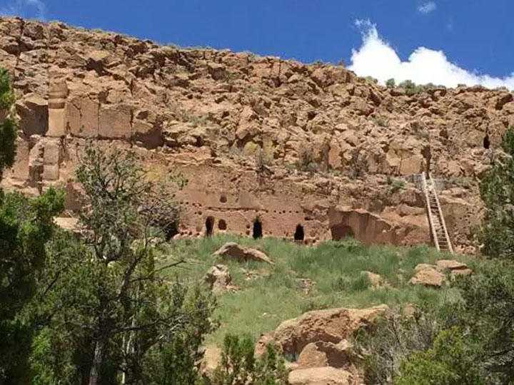
A view of the Tijeras Pueblo Archaeological Site
The closest town to Rancho Verde is Tijeras which was so named by the Spanish when they arrived in 1540 and discovered the Pueblo (“village”) People who had lived there since the 1,300’s. The Spanish settled to the North in what is known as Santa Fe and through their missions extended the reach of the Catholic Church throughout the surrounding southwest. The word “Tijeras” means scissors and derives its meaning from the scissor like land formation resulting from the intersection of the Carnué and Cedro Canyons. The small community known as Carnuel (variously spelt as Carnué) likely derives its name from the Tiwa word (the Tiwa Pueblioan ethnic group of N.M.) which means “badger place”. Carnué/Carnuel Canyon became commonly known as Tijeras Canyon and as it continued eastward it became known as the Tablazon Canyon and then further eastward as the Sedillo Canyon.
Significantly, Tijeras is located directly above a geological fault, the deep and narrow Tijeras Canyon, which runs east to west separating the area into the Sandia Mountains to its north and the Manzano Mountains to its south.
During the revolt of the Pueblo People’s of 1680 the missions and small towns were destroyed. The Spanish returned in 1690 to rebuild and exert their control over Nueva Mejico, since anglicized to New Mexico.
Settlers started arriving in the area from the east by 1819 but had to endure harsh conditions including the peril of Comanche and Apache raids. After the Mexican-American War of 1846 to 1848, the U.S. Federal Government incorporated the area as the “Territory of New Mexico” which led to a further influx of settlers from the east. By 1880 there were 15 families homesteading in the area and the Catholic Church was built in 1912. By 1926 the old native trail and wagon road had become highway US 470 which ultimately became part of historic Route 66.
The Rancho Verde land sub-division is located in the East Mountains (east of Albuquerque, NM in Bernalillo County) in a climate area referred to as “high dessert” and is 5 minutes by car south of Old Route 66. Rancho Verde features a variety of terrain with view lots, open green spaces, and endlessly stunning sunrises and sunsets. The mountain community is heavily treed with mature pinion trees which in times past were harvested by the Pueblo People for their rich pine nuts, still popular today.